 Bartholomew 1899

|

|
|
|
item:- JandMN (319) image:- © see bottom of page |
click to enlarge |
|
|
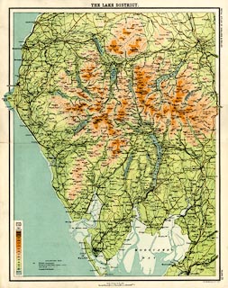
Map, colour lithograph, The Lake District, scale about 3
miles to 1 inch, by John Bartholomew, Edinburgh, Lothian,
1899-1900.
Plate 21 from the Royal Atlas of England and Wales; includes parts of Westmorland, Cumberland and Lancashire.. |
||

|
Bartholomew 1899 | |
| map feature:- | table of symbols & up is N & scale line & sea tinted & coast line & rivers & lakes & relief & contours & layer colouring & table of heights & settlements & roads & railways & canals | |
| inscription:- |
printed top centre
THE LAKE DISTRICT. |
|
| inscription:- |
printed right side
ROYAL ATLAS OF ENGLAND & WALES / PLATE 21 |
|
| inscription:- |
printed bottom right
John Bartholomew & Co. Edinr. |
|
| inscription:- |
printed with scale line
SCALE 3 MILES TO AN INCH. |
|
| scale line:- | 6 miles = 50.4 mm | |
| scale:- | 1 to 190000 ? (1 to 191589 from scale line) | |
| wxh, sheet:- | cm | |
| wxh, map:- | mm | |