 Smith 1826

|

|
|
|
item:- JandMN (307) image:- © see bottom of page |
click to enlarge |
|
|
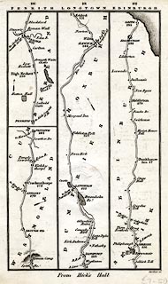
Strip map, road map, a road through Appleby, Westmorland,
ending Penrith, Cumberland, and the road from Penrith,
Cumberland, to Edinburgh, scale about 8 or 9 miles to 1
inch, engraved by Gardner, published by Charles Smith and
Son, 172 Strand, London, 1826.
Published in Smith's New Pocket Companion to the Roads of England and Wales, and part of Scotland. p.100 - through Brough and Appleby, Westmorland; to Penrith, Cumberland AND from Penrith through Carlisle, Cumberland. p.101 - continued through Longtown, Cumberland; then through Langholm, Hawick, Scotland. p.102 - continued through Selkirk, to Edinnburgh and Leith, Scotland. The distances are from Hick's Hall, London. |
||

|
Smith 1826 | |
| inscription:- |
printed top
100 101 102 / PENRITH LONGTOWN EDINBURGH |
|
| inscription:- |
printed bottom
From Hick's Hall |
|
| wxh, sheet:- | 10.5x17.5cm | |
| wxh, map:- | 93x156mm | |