 Stanford 1885

|

|
|
|
item:- JandMN (312) image:- © see bottom of page |
click to enlarge |
|
|
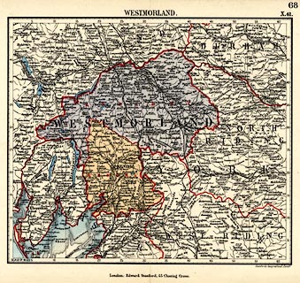
Map, colour lithograph, page 68 or X.41, Westmorland,
scale about 8 miles to 1 inch, published by Edward Stanford,
Stanford's Geographical Establishment, 55 Charing Cross,
London, 1885.
With three pages of text describing Westmorland and its electoral divisions. Included in Stanford's Parliamentary County Atlas of England and Wales, produced by lithographic transfer from Stanford's Library Map of England and Wales, 1881? |
||

|
Stanford 1885 | |
| map feature:- | up is N & scale line (all borders are graduated in miles) & lat and long grid (?) & sea plain & coast tinted & rivers & lakes & forests & county & settlements & roads & railways & canals | |
| inscription:- |
printed top right
68 / X.41. sheet numbers |
|
| inscription:- |
printed top
WESTMORLAND. |
|
| inscription:- |
printed bottom right, centre
Stanford's Geographical Estabt. / London : Edward Stanford, 55 Charing Cross. |
|
| inscription:- |
printed border scale line
SCALE OF MILES |
|
| scale line (bottom border):- | 62 miles = 202.1 mm | |
| scale:- | 1 to 490000 ? (1 to 493713 from scale line, assuming a statute mile) | |