 Bowen 1779

|

|
|
|
item:- Dove Cottage : 2009.81.2 image:- © see bottom of page |
click to enlarge |
|
|
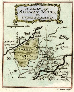
Map, hand coloured engraving, A Plan of Solway Moss,
scale about 1 inch to 1 mile, by Thomas Bowen, published by
the Gentleman's Magazine, London, February 1779.
Tipped in opposite vol.49 p.65. The map accompanies a short report of the eruption of the moss, November 1771, by JF, p.65:- 'Mr URBAN, 'BY giving the following short account of the eruption of Solway Moss a place in your valuable miscellany, you may possibly entertain some of your readers. 'Yours, &c. J. F__R. 'SOME years ago there happened a most dreadful inundation, occasioned by the eruption of Solway Moss, near Longtown, in Cumberland, which did incredible damage in those parts, and considerably changed the aspect of the country. As I lately visited it, I took a draught of the moss, as it now appears, which I send you, with a brief, but I believe as genuine an account as any that has hitherto been given to the public. (See the Plate.) 'It broke out in the night of the 16th of November, 1771:- the inhabitants who lived near it were greatly alarmed with an unusual noise made at its discharge; and, remaining ignorant of the cause of their terror till the morning, some were suprized with it even in their beds, and many by the entrance it made into their houses. About four hundred acres of land were covered with this heathy surface, the houses either overwhelmed or swept away by the current; many cattle were suffocated, but happily not a human life lost: several bridges in this and the neighbouring counties were broke down by the violence of three days rain, which preceded this eruption: people from all parts flocked to see this wonderful phaenomenon, which continued moving slowly for several days, till at last it mixed its stream with the Esk, and totally stopped the course of that river for some time. This black deluge so lowered the surface of the moss, which was before a plain, but now sunk in the form of a vast bastion, as to give to the northern parts new views of land concealed before. '(We are the more readily inclined to oblige our correspondent, as we do not remember to have seen so extensive a plan of the moss and its environs in any other printed account of this eruption - See VolXLI. p.567. Vol.XLII. p.41 Vol.XLIII. p.265. - Phil. Trans. Vol.LXII. p.123.- Pennant's Tour, 1772, p.65,66.) |
||

|
Bowen 1779 | |
| map feature:- | baroque cartouche & north point & up is NW (WNW) & scale line & rivers & settlements & roads | |
| inscription:- |
printed scroll cartouche, upper middle
A PLAN OF / SOLWAY MOSS, / in / CUMBERLAND. |
|
| inscription:- |
printed bottom right
T. Bowen Sculpt. |
|
| inscription:- |
printed with scale line
Scale / 1 Mile |
|
| scale line:- | 1 mile = 24.8 mm | |
| wxh, sheet:- | 13x21cm | |
| wxh, map:- | 103x127mm | |
| scale:- | 1 to 65000 ? (1 to 64893 from scale line, assuming a statute mile) | |