 Housman 1800 map 4

|

|
|
|
item:- JandMN (233_9) image:- © see bottom of page |
click to enlarge |
|
|
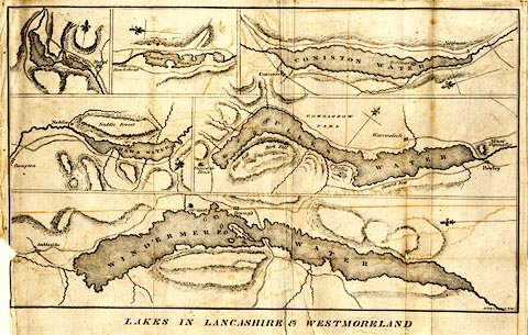
Map, uncoloured engraving, Lakes in Lancashire and
Westmoreland, engraved by McIintyre, Edinburgh, published by
F Jollie, Carlisle, Cumberland, 1800.
There are individual maps; Grasmere Water and Rydal Water, Easthwaite Water, Coniston Water, Haws Water, Ulles Water, Windermere Water. Taken from a guide book, A Descriptive Tour, and Guide to the Lakes, Caves, Mountains, ... by John Housman, 1800, 5th edn 1812. |
||

|
Housman 1800 map 4 | |
| map feature:- | north point & rivers & lakes & relief & hill hachuring & woods & settlements & roads | |
| inscription:- |
printed bottom
LAKES in CUMBERLAND. |
|
| inscription:- |
printed lower right
McIntyre sculpsit Edinr. |
|
| wxh, sheet:- | 33.5x22.5cm | |
| wxh, map:- | 321x193mm | |