 Greenwood 1834

|

|
|
|
item:- JandMN (232) image:- © see bottom of page |
click to enlarge |
|
|
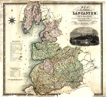
Map, hand coloured engraving, Map of the County Palatine
of Lancaster, scale about 3 miles to 1 inch, by C and J
Greenwood, engraved by J Dower, Pentonville, published by
Greenwood and Co, 13 Regent Street, Pall Mall, London,
1830-34.
|
||

|
Greenwood 1834 | |
| map feature:- | table of symbols & compass rose & up is N & scale line & lat and long scales & sea tinted & sandbanks & coast form lines & rivers & lakes & relief & hill hachuring & woods & parks & county & settlements & roads & turnpike roads & road distances & canals & railways & vignettes | |
| inscription:- |
printed upper right
MAP / OF / THE COUNTY PALATINE OF / LANCASTER, / from an Actual Survey / made in the Year 1818, by C & J GREENWOOD, Published by the Proprietors, / GREENWOOD & CO. / 13, Regent Street, Pall Mall, / LONDON. / Corrected to the present Period and Publish'd Feby. 24th. 1830. / Engraved by J. DOWER, Pentonville, London. |
|
| inscription:- |
printed above scale line
SCALE OF MILES |
|
| scale line:- | 10+1 miles = 91.6 mm | |
| wxh, sheet:- | 83.5x65cm | |
| wxh, map:- | 688x632mm | |
| scale:- | 1 to 190000 ? (1 to 193262 from scale line) | |