 Cooper 1808

|

|
|
|
item:- Dove Cottage : 2009.81.12 image:- © see bottom of page |
click to enlarge |
|
|
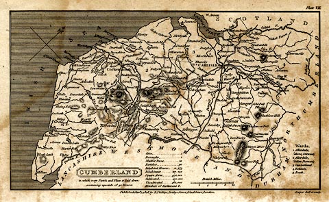
Map, uncoloured engraving, Cumberland, scale about 10.5
miles to 1 inch, drawn and engraved by Cooper, published by
R Phillips, Bridge Street, Blackfriars, London, 1808.
Plate 7. |
||

|
Cooper 1808 | |
| map feature:- | plain cartouche & table of data & north point & up is NW & scale line & sea shaded & coast line & rivers & lakes & relief & hill hachuring & county & settlements & roads | |
| inscription:- |
printed title cartouche and below
CUMBERLAND / in which every Parish and Place is laid down / containing upwards of 40 Houses. |
|
| inscription:- |
printed bottom centre and right
Published Jany. 1, 1808, by R. Phillips, Bridge Street, Blackfriars, London. / Cooper delt. et sculp. |
|
| inscription:- |
printed with scale line
British Miles |
|
| scale line:- | 10 miles = 24.3 mm | |
| scale:- | 1 to 660000 ? (1 to 662281 from scale line) | |
| wxh, sheet:- | 21.5x13cm | |
| wxh, map:- | 180x103mm | |