 Dugdale 1835

|

|
|
|
item:- Dove Cottage : 2009.81.9 image:- © see bottom of page |
click to enlarge |
|
|
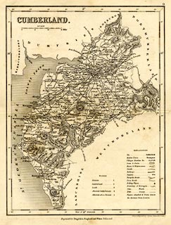
Map, uncoloured engraving, Cumberland, scale about 8.5
miles to 1 inch, by J Archer, Pentonville, London, about
1835, later edition with railways.
Published as plate 9 in Curiosities of Great Britain, England and Wales Delineated, by Thomas Dugdale, 1835. |
||

|
Dugdale 1835 | |
| map feature:- | table of symbols & up is N & scale line & lat and long scales & sea plain & coast shaded & rivers & lakes & relief & hill hachuring & forests & parks & county & wards (hundreds) & table of wards (hundreds) & settlements & roads & railways & canals | |
| inscription:- |
printed upper left
CUMBERLAND. |
|
| inscription:- |
printed bottom, centre and right
Engraved for Dugdale's England and Wales Delineated. / Drawn & Engraved by J. Archer Pentonville London. |
|
| inscription:- |
printed with scale line
SCALE / Miles |
|
| scale line:- | 15 miles = 44.4 mm | |
| scale:- | 1 to 540000 ? (1 to 543697 from scale line) | |
| wxh, sheet:- | 22x26.5cm | |
| wxh, map:- | 177x233mm | |