 Hall 1833

|

|
|
|
item:- Dove Cottage : 2009.81.7 image:- © see bottom of page |
click to enlarge |
|
|
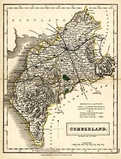
Map, hand coloured engraving, Cumberland, scale about 8
miles to 1 inch, by Sidney Hall, published by Chapman and
Hall, 193 Piccadilly, London, about 1860s.
The map, first published 1833, is probably from the Travelling County Atlas or the New County Atlas by Sidney Hall, as engraved uptodate for the 1840s but with manuscript additions, coloured railways to the 1860s. Notice that the canal from Carlisle to Bowness is still shown, not yet altered to a railway. |
||

|
Hall 1833 | |
| map feature:- | plain cartouche & north point & scale line & lat and long scales & sea plain & coast shaded & rivers & lakes & relief & hill hachuring & parks & county & wards (hundreds) & table of wards (hundreds) & settlements & roads & railways & canals | |
| inscription:- |
printed title cartouche etc, lower right
CUMBERLAND. / ENGRAVED BY SIDY. HALL. |
|
| inscription:- |
printed bottom
London, Published by Chapman & Hall, 193 Piccadilly. |
|
| inscription:- |
printed with scale line
English Miles. |
|
| scale line:- | 16 miles = 52.2 mm | |
| scale:- | 1 to 490000 ? (1 to 493286 from scale line) | |
| wxh, sheet:- | 20.5x27.5cm | |
| wxh, map:- | 190x245mm | |