 Dispatch 1863

|

|
|
|
item:- JandMN (227) image:- © see bottom of page |
click to enlarge |
|
|
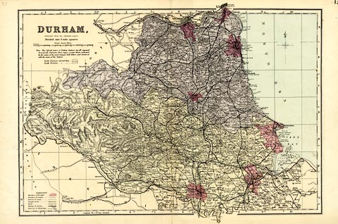
Map, colour lithograph, Durham, scale about 3 miles to 1
inch, first drawn by Edward Weller for the Weekly Dispatch
newspaper, 1856-62, published by G W Bacon, Bacon's
Geographical Establishment, London, 1895-97.
Plate ? in the Commercial and Library Atlas of the British Isles. Version of this map were published from 1850s to 1930s. |
||

|
Dispatch 1863 | |
| map feature:- | up is N & scale line & lat and long scales (trapezoidal projection) & index grid (1..10, A..N) & table of symbols & table of data (population) & sea tinted & coast tinted & rivers & relief & hill hachuring & parks & county & electoral data & settlements & roads & canals & railways | |
| inscription:- |
printed upper right
DURHAM / REDUCED FROM THE ORDNANCE SURVEY / Divided into 5 miles squares |
|
| inscription:- |
printed above scale line
British Statute Miles |
|
| scale line:- | 10+1 miles = 90.0 mm | |
| scale:- | 1 to 200000 ? (1 to 196698 from scale line) | |
| wxh, sheet:- | 53x34cm | |
| wxh, map:- | 458x311mm | |