 Dawson 1830s

|

|
|
|
item:- Carlisle Library : Map 126 image:- © Carlisle Library |
click to enlarge |
|
|
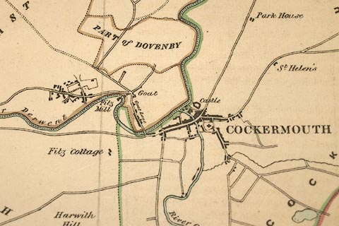
Map, hand coloured lithograph, Cockermouth, proposed new
boundary, scale about 2 inches to 1 mile, by Captain Robert
K Dawson, printed by R Cartwright, London? about 1832.
Drawn by G G Chapell; for the Reform Act 1832. The table of symbols has - 'Explanations / Boundary of Old Borough ... Green / Proposed Boundary ... Red / Boundaries of Parishes and Townships ... Brown Rivers ... Blue' |
||

|
Dawson 1830s | |
| inscription:- |
printed upper right
COCKERMOUTH. |
|
| inscription:- |
printed lower right
Robt. K. Dawson Lieut. R.E. |
|
| inscription:- |
printed lower right, under scale line
G. G. Chapell Delt. |
|
| inscription:- |
printed bottom
R. Cartwright Lithc. Printer |
|
| inscription:- |
printed with scale line
Scale, 2 inches to 1 Mile |
|
| scale line:- | 1+1 miles = 102.0 mm | |
| wxh, sheet:- | 39.5x35cm | |
| wxh, map:- | 30x29cm | |
| scale:- | 1 to 32000 ? (1 to 31556 from scale line, assuming a statute mile) | |