 Gregson 1821

|

|
|
|
item:- Carlisle Library : Map 74 image:- © Carlisle Library |
click to enlarge | |
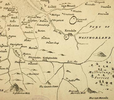
| Illustration of part of map only. | ||
|
Map, uncoloured lithograph, Lancashire 1598, scale about
3 miles to 1 inch, copied from British Library, Harleian MSS
6159, by Matthew Gregson, engraved by James Wyld, 1821,
published 1824.
Printed by The Lithographic Press, 6 Dartmouth Street, Westminster, London. Perhaps a late addition to a set of prints Fragments of the History of Lancashire published Liverpool, Lancashire, from 1816. Said to be worse than useless, falsifying the WSR manuscript. |
||

|
Gregson 1821 | |
| map feature:- | plain cartouche & up is W (roughly) & scale line & descriptive text & sea plain & galleons & coast line & foreshore sands & rivers & bridges (no roads) & lakes & relief & hillocks & forests & parks & county & settlements | |
| inscription:- |
printed upper centre
For Gregson's Fragments of / LANCASHIRE, 1598, WSR. / Copied from a Drawing. No.6159 HL. MSS. by M. Gregson 1821. |
|
| inscription:- |
printed lower right
Jas Wyld delt |
|
| inscription:- |
printed bottom left
The Lithographic Press, 6, Darrtmouth St. Westr. |
|
| scale line:- | 10 miles = 79.7 mm | |
| wxh, sheet:- | 56x43.5cm | |
| wxh, map:- | 482x335mm | |
| scale:- | 1 to 200000 ? (1 to 201925 from scale line, assuming a statute mile) | |