 Marr 1916 map

|

|
|
|
item:- JandMN (173_3) image:- © see bottom of page |
click to enlarge |
|
|
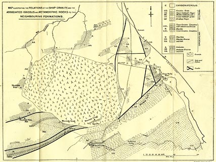
Geological map, uncoloured lithograph, Map Illustrating
... The Shap Granite ..., scale about 3.5 inches to 1 mile,
by J E Marr, published by Cambridge University Press,
Cambridge, Cambridgeshire, 1916.
Folded and tipped in opposite p.90 in The Geology of the Lake District. |
||

|
Marr 1916 map | |
| map feature:- | north point & up is N & rivers & relief & settlements & roads & railways & geology & stratigraphical column | |
| inscription:- |
printed upper left
MAP ILLUSTRATING THE RELATIONSHIP OF THE SHAP GRANITE AND THE / ASSOCIATED IGNEOUS AND METAMORPHIC ROCKS TO THE / NEIGHBOURING FORMATIONS. |
|
| inscription:- |
printed bottom right
Cambridge University Press |
|
| inscription:- |
printed above scale line
ONE MILE |
|
| scale line:- | 1 mile = 82.1 mm | |
| wxh, sheet:- | 44x34.5cm | |
| wxh, map:- | 341x259mm | |
| scale:- | 1 to 20000 ? (1 to 19602 from scale line) | |