 Marr 1916 map

|

|
|
|
item:- JandMN (173_2) image:- © see bottom of page |
click to enlarge |
|
|
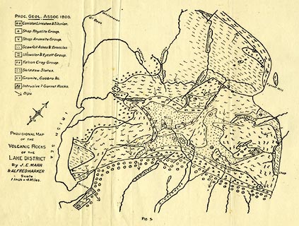
Geological map, uncoloured lithograph, Provisional Map of
the Volcanic Rocks of the Lake District, scale about 4 miles
to 1 inch, by J E Marr and Alfred Harker, published by
Cambridge University Press, Cambridge, Cambridgeshire, 1916.
Folded and tipped in opposite p.17 in The Geology of the Lake District. |
||

|
Marr 1916 map | |
| map feature:- | north point & up is NW & sea plain & coast line & rivers & lakes & geology & stratigraphical column | |
| inscription:- |
printed lower left
PROVISIONAL MAP / OF THE / VOLCANIC ROCKS / OF THE / LAKE DISTRICT / BY J. E. MARR / & ALFRED HARKER |
|
| wxh, sheet:- | 32.5x22cm | |