 Postlethwaite 1877 map 2

|

|
|
|
item:- JandMN (162_2) image:- © see bottom of page |
click to enlarge |
|
|
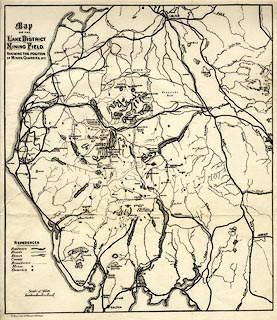
Map, uncoloured engraving, Map of the Lake District
Mining Field, scale about 5 miles to 1 inch, by John
Postlethwaite, published by W H Moss and Sons, 13 Lowther
Street, Whitehaven, Cumberland, 1877 edn 1913.
Folded and tipped in opposite p.74 of Mines and Mining in the English Lake District. |
||

|
Postlethwaite 1877 map 2 | |
| map feature:- | table of symbols & up is N & scale line & sea plain & coast form lines & rivers & lakes & relief & hill hachuring & county & settlements & roads & railways & mines | |
| inscription:- |
printed upper left
Map / OF THE / LAKE DISTRICT / MINING FIELD. |
|
| inscription:- |
printed bottom left
W. H. Moss & Sons Ltd. Whitehaven & Workington. |
|
| inscription:- |
printed above scale line
Scale of Miles. |
|
| scale line:- | 5 miles = 26.3 mm | |
| scale:- | 1 to 310000 ? (1 to 305959 from scale line) | |
| wxh, sheet:- | 27x32cm | |
| wxh, map:- | 253x288mm | |