 Garnett 1850s-60s C

|

|
|
|
item:- JandMN (149_7) image:- © see bottom of page |
click to enlarge |
|
|
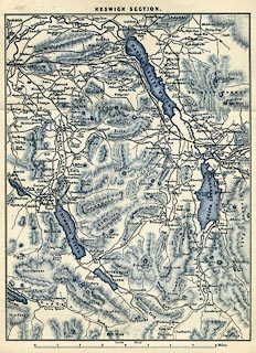
Map, blue engraving, Keswick Section, scale about 2 miles
to 1 inch, engraved by William Banks, Edinburgh, published
by John Garnett, Windermere, Westmorland, and by Simpkin,
Marshall and Co, London, 2nd edn 1860s?
Folded and tipped in opposite p.65 of A Guide to the English Lake District, by a Cambridge Man. |
||

|
Garnett 1850s-60s C | |
| inscription:- |
printed top
KESWICK SECTION. |
|
| inscription:- |
printed bottom
Banks Edinr. |
|
| scale line:- | 8 miles = 105.1 mm | |
| wxh, sheet:- | 16.5x21cm | |
| wxh, map:- | 142x188mm | |
| scale:- | 1 to 120000 ? (1 to 122500 from scale line) | |