 Bowen 1763

|

|
|
|
item:- Armitt Library : ALMC2008.14.121 image:- © see bottom of page |
click to enlarge |
|
|
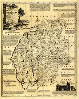
Map, uncoloured engraving, Improved Map of the Counties
of Cumberland and Westmoreland, by Emanuel Bowen, scale
about 5.5 miles to 1 inch, published by Robert Sayer and
John Bennett, 53 Fleet Street, John Bowles, 13 Cornhill, and
Carrington Bowles, 69 St Paul's Churchyard, London, 1777-78.
Included in The Royal English Atlas: Being A New and Accurate Set of Maps Of All The Counties of South Britain. The map is reduced from a larger map by Emanuel Bowen or Thomas Kitchin. |
||

|
Bowen 1763 | |
| map feature:- | monumental cartouche & vignettes & descriptive text & table of symbols & compass rose (aligned to lat and long grid) & up is N & scale line & lat and long scales (West Long. from London; rectangular projection) & lat and long grid & sea plain & coast shaded & rivers & bridges & lakes & relief & hillocks & woods & forests & parks & county & wards & settlements & roads & post roads & road distances & market days | |
| inscription:- |
printed monumental cartouche, upper left
An IMPROVED MAP of / the COUNTIES of / CUMBERLAND / and / WESTMORELAND / Divided into their respective / WARDS. / Drawn from the best Authorities, / Adorned with a VIEW of the / Cathedral Church of Carlile, / with some account of the Diocese, / & other Historical Extracts. / By Eman : Bowen / Geograpr. to His late Majesty. a ruin in a scene with lake and mountains, bolts of woollen cloth, straw hats |
|
| inscription:- |
printed bottom
London Printed for Robt. Sayer & John Bennett, No.53, Fleet Stret, John Bowles, No.13, Cornhill, & Carrington Bowles, No.69 St Pauls Church Yard, as the Act directs, 1st. June 1777. |
|
| inscription:- |
printed above scale line
British Statute Miles |
|
| scale line:- | 16 miles = 77.1 mm | |
| longitude, Kendal:- | 2d 50.8m W | |
| scale:- | 1 to 330000 ? (1 to 333975 from scale line) | |
| wxh, sheet:- | 46x55cm | |
| wxh, plate:- | 416x514mm | |
| wxh, map:- | 402x501mm | |