 Rowe 1816

|

|
|
|
item:- Armitt Library : ALMC2008.14.93 image:- © see bottom of page |
click to enlarge |
|
|
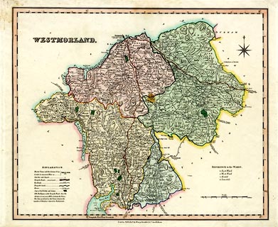
Map, hand coloured engraving, Westmorland, scale about 3
miles to 1 inch, by Robert Rowe, published by Henry Teesdale
and Co, 302 Holborn, London, 1829-31.
|
||

|
Rowe 1816 | |
| map feature:- | table of symbols & compass rose & up is N & scale line & lat and long scales (rectangualr projection; Longitude West from Greenwich) & sea plain & coast line & rivers & lakes & relief & hill hachuring & woods & forests & parks & county & wards & table of wards & electoral data & settlements & roads & turnpike roads & post roads & road distances & distances from London & canals | |
| inscription:- |
printed upper left
WESTMORLAND fancy font |
|
| inscription:- |
printed bottom
London, Published by Henry Teesdale & Co. 302 Holborn. |
|
| inscription:- |
printed with scale line
Scale. Miles |
|
| scale line:- | 8+1 miles = 74.5 mm | |
| scale:- | 1 to 190000 ? (1 to 191842 from scale line) | |
| wxh, sheet:- | 47x37cm | |
| wxh, map:- | 413x340mm | |