 Teesdale 1830

|

|
|
|
item:- Armitt Library : ALMC2008.14.92 image:- © see bottom of page |
click to enlarge |
|
|
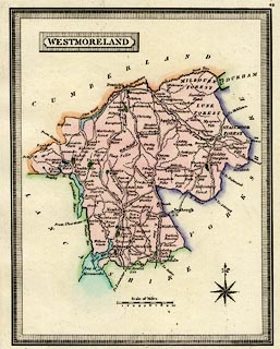
Map, hand coloured engraving, Westmoreland ie
Westmorland, scale about 8 miles to 1 inch, published by
Henry Teesdale and Co, 302 Holborn, London, 1830.
|
||

|
Teesdale 1830 | |
| map feature:- | piano key border & plain cartouche & compass rose & up is N & scale line & sea plain & coast tinted & rivers & lakes & parks & county & settlements & roads & canals | |
| inscription:- |
printed title cartouche, upper left
WESTMORELAND |
|
| scale line:- | 10 miles = 31.3 mm | |
| scale:- | 1 to 510000 ? (1 to 514167 from scale line) | |
| wxh, sheet:- | 21.5x27cm | |
| wxh, plate:- | 159x203mm | |
| wxh, map:- | 148x189mm | |