 Wilkes 1801-28

|

|
|
|
item:- Armitt Library : ALMC2008.14.81 image:- © see bottom of page |
click to enlarge |
|
|
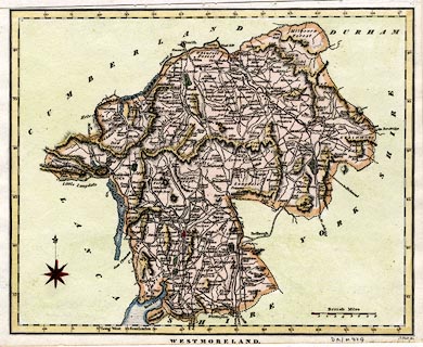
Map, hand coloured engraving, Westmoreland ie
Westmorland, scale about 5 miles to 1 inch, by John Wilkes,
engraved by J Pass, published J Adlard, Duke Street, West
Smithfield, London, 1828.
Included in the Encyclopaedia Londinensis by John Wilkes. |
||

|
Wilkes 1801-28 | |
| map feature:- | compass rose & up is N & scale line & lat and long scales & coast shaded & rivers & relief & lakes & hill hachuring & parks & county & settlements & roads & canals | |
| inscription:- |
printed bottom right
J. Pass sc. |
|
| inscription:- |
printed bottom centre
WESTMORELAND. / Engraved for the Encyclopaedia Londinensis. 1828. |
|
| inscription:- |
printed above scale line
British Miles |
|
| scale line:- | 8 miles = 38.7 mm | |
| longitude, Kendal:- | 2d 44.5m W | |
| scale:- | 1 to 330000 ? (1 to 332681 from scale line) | |
| wxh, sheet:- | 26.5x20.5cm | |
| wxh, map:- | 244x196mm | |