 Cooke 1802

|

|
|
|
item:- Armitt Library : ALMC2008.14.77 image:- © see bottom of page |
click to enlarge |
|
|
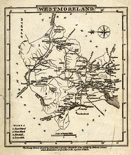
Map, uncoloured engraving, Westmoreland ie Westmorland,
scale about 12 miles to 1 inch, by George Cooke, 17
Paternoster Row, London, 1802-10.
Included in one of a series, The Modern British Traveller: or, Tourist's Pocket Directory issued volume at a time 1802-10. |
||

|
Cooke 1802 | |
| map feature:- | plain cartouche & compass rose & up is E & scale line & lat and long scales (beware the longitude minute numbering is wrong) & coast form lines & rivers & lakes & parks & county & wards & table of wards & settlements & roads & distances from London | |
| inscription:- |
printed title cartouche, top
WESTMORELAND |
|
| inscription:- |
printed above scale line
Scale of Statute Miles |
|
| scale line:- | 10 miles = 21.7 mm | |
| longitude, Kendal:- | 2d 54m W (?) | |
| wxh, sheet:- | 12.5x14.5cm | |
| wxh, map:- | 109x123mm | |
| scale:- | 1 to 740000 ? (1 to 741633 from scale line) | |