 Bickham 1753-54

|

|
|
|
item:- Armitt Library : ALMC2008.14.71 image:- © see bottom of page |
click to enlarge |
|
|
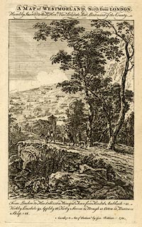
Map, uncoloured engraving, perspective view, A Map of
Westmorland, North from London, by George Bickham, James
Street, Bunhill Fields, London, 1753.
The map and the attached descriptive text were included in The British Monarchy or a New Chorographical Description of all the Dominions Subject to the King of Great Britain, issued in parts from 1743. Any attempt to 'undo' the perspective and make a plan diagram will fail. |
||

|
Bickham 1753-54 | |
| inscription:- |
printed top
A MAP of WESTMORLAND. North from LONDON. / Humbly Inscribed to the Rt. Honble : Visct. Lonsdale, Lord Lieutenant of the County. |
|
| inscription:- |
printed bottom
From London to Kendall 256m. Principal Town from Kendal Ambleside 13 / Kirkby Lonsdale 9. Appleby 26. Kirkby Steven 21. Brough 12. Orton 15. Burton 12. / Shap 18. / According to Act of Parliamt. by Geo. Bickham 1753. |
|
| wxh, sheet:- | 19.5x31.5cm | |
| wxh, plate:- | 156x256mm | |
| wxh, map:- | 148x211mm | |