 Smith 1804

|

|
|
|
item:- Armitt Library : ALMC2008.14.70 image:- © see bottom of page |
click to enlarge |
|
|
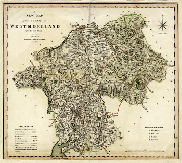
Map, hand coloured engraving, New Map of the County of
Westmoreland ie Westmorland, scale about 2.5 miles to 1
inch, published by Charles Smith, 172 Strand, London, 1804.
Included in the first edition of Smith's New English Atlas, 1804. The map has been badly trimmed and new paper added at the edges to repair it. |
||

|
Smith 1804 | |
| map feature:- | compass rose & up is N & scale line & lat and long scales & coast form lines & rivers & lakes & relief & hill hachuring & forests & parks & county & wards & settlements & roads & road distances & turnpike roads & distances from London & canals & table of symbols & table of wards | |
| inscription:- |
printed
A / NEW MAP / of the COUNTY of / WESTMORELAND / Divided into Wards. / LONDON / Printed for C. SMITH No.172 Strand. / January 6th. 1804. |
|
| scale line:- | 8+1 miles = 98.6 mm | |
| longitude, Kendal:- | 2d 47.25m W | |
| scale:- | 1 to 150000 ? (1 to 147346 from scale line assuming a statute mile) | |