 Lodge 1788-90

|

|
|
|
item:- Armitt Library : ALMC2008.14.64 image:- © see bottom of page |
click to enlarge |
|
|
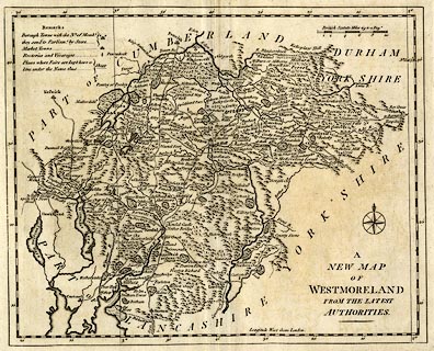
Map, uncoloured engraving, A New Map of Westmoreland,
scale about 5 miles to 1 inch, engraved by John Lodge,
published by R Butters, Fleet Street, London, 1795.
An earlier edition of the map appeared in the Political Magazine, 1790. |
||

|
Lodge 1788-90 | |
| map feature:- | table of symbols & compass rose & up is N & scale line & lat and long scales (rectangular projection) & lat and long grid (minimal) & sea plain & coast shaded & rivers & lakes & relief & hillocks & woods & forests & parks & county & settlements & roads | |
| inscription:- |
printed lower right
A / NEW MAP / OF / WESTMORELAND / FROM THE LATEST / AUTHORITIES. |
|
| inscription:- |
printed above scale line
Brtish Statute Miles 69 to a Dege. |
|
| scale line:- | 10 miles = 53.0 mm | |
| longitude, Kendal:- | 2d 51m W | |
| wxh, sheet:- | 36x30.5cm | |
| wxh, plate:- | 333x275mm | |
| wxh, map:- | 318x257mm | |
| scale:- | 1 to 300000 ? (1 to 303650 from scale line wrongly assuming a statute mile) | |