 Duncan 1833

|

|
|
|
item:- Armitt Library : ALMC2008.14.53 image:- © see bottom of page |
click to enlarge |
|
|
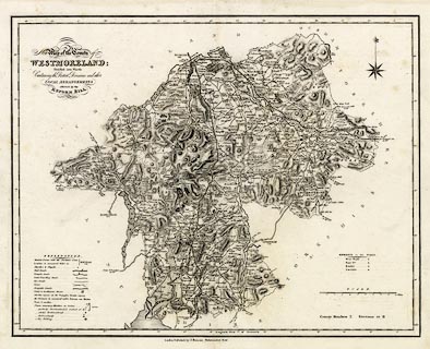
Map, uncoloured engraving, New Map of the County of
Westmoreland ie Westmorland, scale about 3 miles to 1 inch,
pertaining to the Reform Bill, probably by William Ebden,
engraved by Hoare and Reeves? published by James Duncan,
Paternoster Row, London, 1833.
Included in a Complete County Atlas of England and Wales. |
||

|
Duncan 1833 | |
| map feature:- | table of symbols & compass rose & up is N & scale line & lat and long scales (rectangular projection? longitude from Greenwich) & sea plain (?) & coast shaded & rivers & lakes & relief & hill hachuring & forests & parks & county & wards & table of wards & electoral data & settlements & roads & road distances & post roads & turnpike roads & canals | |
| inscription:- |
printed title. upper left
New Map of the County of / WESTMORELAND; / Divided into Wards / Containing the District Divisions and other / LOCAL ARRANGEMENTS / affected by the / REFORM BILL. |
|
| inscription:- |
printed bottom
London. Published by James Duncan Paternoster Row. |
|
| inscription:- |
printed with scale line
SCALE. / Miles |
|
| scale line:- | 10 miles = 83.0 mm | |
| longitude, Kendal:- | 2d 44m W | |
| wxh, sheet:- | 49x39.5cm | |
| wxh, map:- | 444x347mm | |
| scale:- | 1 to 190000 ? (1 to 193897 from scale line wrongly assuming a statute mile) | |