 Cooper 1808

|

|
|
|
item:- Armitt Library : ALMC2008.14.47 image:- © see bottom of page |
click to enlarge |
|
|
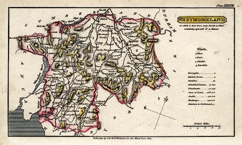
Map, hand coloured engraving, Westmoreland ie
Westmorland, scale about 9 miles to 1 inch, by H Cooper,
1808, published by G and W B Whittaker, 13 Ave Maria Lane,
London, 1824.
Includeded in A Topographical Dictionary of the United Kingdom, by Benjamin Pitts Capper, London, 1808 in the edition of 1825. Plate 37. |
||

|
Cooper 1808 | |
| map feature:- | plain cartouche & sea shaded & coast line & north point & up is N (NNW) & scale line & rivers & lakes & relief & hill hachuring & county & wards (hundreds) & table of wards & settlements & roads & canals & population data | |
| inscription:- |
printed bottom centre
Published by G. & W. B. Whittaker, 13, Ave Maria Lane, 1824. |
|
| inscription:- |
printed upper right, plain title cartouche, and underneath
WESTMORELAND / in which is laid down every Parish & Place / containing upwards of 20 Houses. |
|
| inscription:- |
printed above scale line
British Miles. |
|
| scale line:- | 10 miles = 28.9 mm | |
| scale:- | 1 to 560000 ? (1 to 556866 from scale line) | |
| wxh, sheet:- | 22x12.5cm | |
| wxh, plate:- | 200x121mm (?) | |
| wxh, map:- | 180x102mm | |