 Blome 1673

|

|
|
|
item:- Armitt Library : ALMC2008.14.37 image:- © see bottom of page |
click to enlarge |
|
|
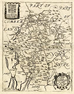
Map, uncoloured engraving, Mapp of ye Countie of
Westmorland, scale about 3 miles to 1 inch, by Richard
Blome, probably engraved by Richard Palmer, published,
London, 1673.
The map has a dedication to and the coat of arms of Sir John Lowther. From Britannia: or, A Geographical Description of the Kingdoms of England, Scotland, and Ireland, ... |
||

|
Blome 1673 | |
| map feature:- | labelled borders & scroll cartouche & up is N & scale line & sea plain & coast shaded & rivers & lakes & relief & hillocks & parks & county & settlements | |
| inscription:- |
printed title cartouche, lower right
A MAPP / OF YE COUNTYE OF / WESTMORLAND / DESCRIBED / BY RIC : BLOME / BY HIS MATY / COMAND |
|
| inscription:- |
printed drape cartouche, upper left; coat of arms, including
the Lowther arms 'or six annulets sable, 3,2,1'
To The Honeble Sr. John / Lowther Seinour of / Lowther Hall Bart, / This Mapp is Humbly / Dedicated by Ric : Blome. |
|
| inscription:- |
printed with scale line
A Scale of 6 Miles |
|
| scale line:- | 6 miles = 49.2 mm | |
| inscription:- | watermark: not understood | |
| scale:- | 1 to 200000 ? (1 to 196261 from scale line wrongly assuming a statute mile) | |
| wxh, sheet:- | 32x37.5cm | |
| wxh, plate:- | 252x322mm | |
| wxh, map:- | 248x318mm | |

|
||

|
||