 Lewis 1831

|

|
|
|
item:- Armitt Library : ALMC2008.14.23 image:- © see bottom of page |
click to enlarge |
|
|
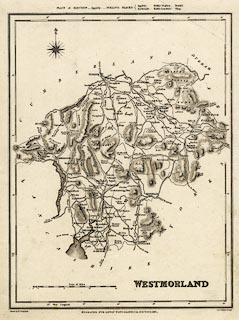
Map, uncoloured engraving, Westmorland, scale about 6.5
miles to 1 inch, drawn by R Creighton, engraved by John and
Charles Walker, published by Samuel Lewis and Co, 87
Aldersgate Street, London, from 1831, edn 1833.
from A Topographical Dictionary of England. In this edition the map has a note of places of election and polling places added at the top, and wards are shown and named in a table lower right. |
||

|
Lewis 1831 | |
| map feature:- | compass rose & scale line & lat and long scales & coast form lines & rivers & lakes & relief & hill hachuring & county & wards & table of wards & settlements & roads & canals & electoral data | |
| inscription:- |
printed lower right
WESTMORLAND |
|
| inscription:- |
printed bottom left, centre, right
Drawn by R. Creighton / ENGRAVED FOR LEWIS' TOPOGRAPHICAL DICTIONARY. / J. & C. Walker Sculpt. |
|
| scale line:- | 15+1 miles = 64.2 mm | |
| wxh, sheet:- | 24x31cm | |
| wxh, plate:- | 202x253mm | |
| wxh, map:- | 174x228mm | |
| scale:- | 1 to 400000 ? (1 to 401083 from scale line) | |