 Reynolds 1860s

|

|
|
|
item:- Armitt Library : A4027.18 image:- © see bottom of page |
click to enlarge |
|
|
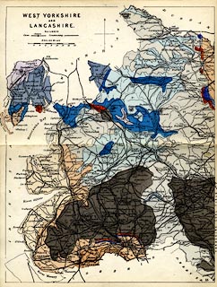
Geological map, hand coloured engraving, West Yorkshire
and Lancashire, scale about 10 miles to 1 inch, published by
James Reynolds, 174 Strand, London, 1860s.
Plate 18 in Reynolds's Geological Atlas of Great Britain, coloured on a base map engraved by John Emslie, published by James Reynolds, 1848 onwards. |
||

|
Reynolds 1860s | |
| map feature:- | north point & up is N & scale line & table of symbols (for railways only, built and building) & sea plain & coast line & rivers & county & settlements & railways & geology & stratigraphical column | |
| inscription:- |
printer upper left
WEST YORKSHIRE / AND / LANCASHIRE. |
|
| inscription:- |
printed lower right
18 plate number |
|
| inscription:- |
printed above scale line
ENGLISH MILES |
|
| scale line:- | 16 miles = 39.6 mm | |
| wxh, sheet:- | 24x18.5cm | |
| wxh, map:- | 174x227mm | |
| scale:- | 1 to 650000 ? (1 to 650240 from scale, line) | |