 Reynolds 1860s

|

|
|
|
item:- Armitt Library : A4027.7 image:- © see bottom of page |
click to enlarge |
|
|
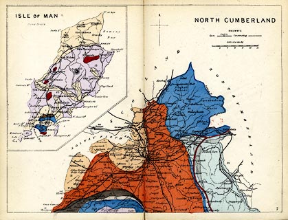
Geological map, hand coloured engraving, North
Cumberland, scale about 8 miles to 1 inch, and the Isle of
Man, published by James Reynolds, 174 Strand, London, 1860s.
Plate 7 in Reynolds's Geological Atlas of Great Britain, coloured on a base map engraved by John Emslie, published by James Reynolds, 1848 onwards. |
||

|
Reynolds 1860s | |
| map feature:- | north point & up is N & scale line & table of symbols (for railways only, built and building) & sea plain & coast line & rivers & county & settlements & railways & geology & stratigraphical column | |
| inscription:- |
printer upper right
NORTH CUMBERLAND |
|
| inscription:- |
printed upper left
ISLE OF MAN |
|
| inscription:- |
printed lower right
7 plate number |
|
| inscription:- |
printed above scale line
ENGLISH MILES |
|
| scale line:- | 12 miles = 38.0 mm | |
| wxh, sheet:- | 24x18.5cm | |
| wxh, map:- | 226x170mm | |
| scale:- | 1 to 510000 ? (1 to 508214 from scale, line) | |