 Reynolds 1860s

|

|
|
|
item:- Armitt Library : A4027.1 image:- © see bottom of page |
click to enlarge |
|
|
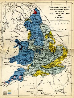
Geological map, hand coloured engraving, England and
Wales, scale about 54 miles to 1 inch, published by James
Reynolds, 174 Strand, London, 1860s.
Plate 1 in Reynolds's Geological Atlas of Great Britain, coloured on a base map engraved by John Emslie, published by James Reynolds, 1848 onwards. |
||

|
Reynolds 1860s | |
| map feature:- | up is N & scale line & lat and long scales (conical projection; longitude from Greenwich) & lat and long grid & sea plain & coast line & county & settlements & railways & geology & stratigraphical column | |
| inscription:- |
printer upper right
ENGLAND AND WALES / WITH THE CHANNEL ISLANDS / AND PARTS OF / SCOTLAND, IRELAND / AND / FRANCE |
|
| inscription:- |
printed lower right
1 plate number |
|
| inscription:- |
printed above scale line
ENGLISH MILES |
|
| scale line:- | 100 miles = 47.0 mm | |
| wxh, sheet:- | 18.5x24cm | |
| wxh, map:- | 170x227mm | |
| scale:- | 1 to 3400000 ? (1 to 3424136 from scale line) | |