 Duncan 1833

|

|
|
|
item:- private collection (70) image:- © see bottom of page |
click to enlarge |
|
|
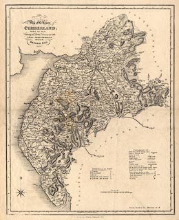
Map, uncoloured engraving, New Map of the County of
Cumberland, scale about 4 miles to 1 inch, by William Ebden,
altered and published by James Duncan, Paternoster Row,
London, 1833.
Corrected to shows the effects of the Reform Act, 1832. |
||

|
Duncan 1833 | |
| map feature:- | table of symbols & compass rose & up is N & scale line & lat and long scales & sea plain & coast shaded & rivers & lakes & relief & hill hachuring & woods & forests & parks & county & electoral data & settlements & roads | |
| inscription:- |
printed upper left
New Map of the County of / CUMBERLAND; / Divided into Wards, / Containing the District Divisions and other / LOCAL ARRANGEMENTS / effected by the / REFORM BILL |
|
| inscription:- |
printed bottom
[London Published by] J. Duncan. Paternoster Row |
|
| scale line:- | 10 miles = 59.1 mm | |
| scale:- | 1 to 270000 ? (1 to 272309 from scale line) | |
| wxh, sheet:- | 39.5x49cm | |
| wxh, map:- | 350x439mm | |