 Rowe 1816

|

|
|
|
item:- private collection (69) image:- © see bottom of page |
click to enlarge |
|
|
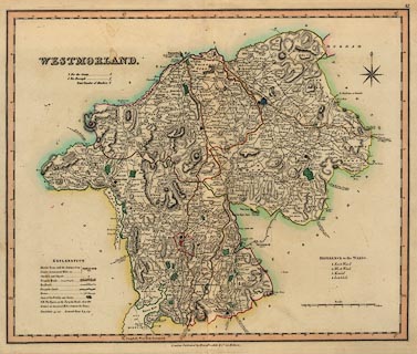
Map, hand coloured engraving, Westmorland, scale about 3
miles to 1 inch, by Robert Rowe, published by Henry Teesdale
and Co, 302 Holborn, London, 1830s.
The map has electoral data after the Reform Act 1832. Plate 42 from? |
||

|
Rowe 1816 | |
| map feature:- | table of symbols & compass rose & scale line & lat and long scales & sea plain & coast line & rivers & lakes & relief & hill hachuring & woods & forests & parks & county & electoral data & settlements & roads & canals | |
| inscription:- |
printed top right
42 |
|
| inscription:- |
printed upper left
WESTMORLAND fancy font |
|
| inscription:- |
printed bottom
London, Published by Henry Teesdale & Co. 302 Holborn. |
|
| scale line:- | 8+1 miles = 75.5 mm | |
| scale:- | 1 to 190000 ? (1 to 191842 from scale line) | |
| wxh, sheet:- | 46x37.5cm | |
| wxh, plate:- | 438x366mm | |
| wxh, map:- | 416x343mm | |