 Baker 1791-95

|

|
|
|
item:- JandMN (140) image:- © see bottom of page |
click to enlarge |
|
|
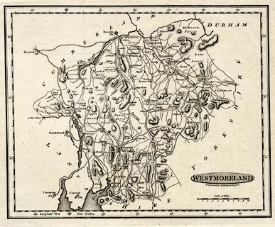
Map, uncoloured engraving, Westmoreland ie Westmorland,
scale about 5.5 miles to 1 inch, engraved by Benjamin Baker,
Islington, London, about 1795.
Opposite p.337 in the Universal Magazine of Knowledge and Pleasure, 2nd issue 1795. |
||

|
Baker 1791-95 | |
| map feature:- | oval cartouche & up is N & scale line & lat and long scales (rectangular projection) & coast form lines & rivers & lakes & relief & hill hachuring & woods & forests & parks & county & settlements & roads | |
| inscription:- |
printed shaded oval cartouche, lower right
WESTMORELAND |
|
| inscription:- |
printed below title cartouche
Engraved by B. Baker, Islington. |
|
| inscription:- |
printed above scale line
Scale of Miles |
|
| scale line:- | 10 miles = 44.8 mm | |
| scale:- | 1 to 360000 ? (1 to 359228 from scale line assuming a statute mile) | |
| wxh, sheet:- | 27x21cm | |
| wxh, plate:- | 243x193mm (?) | |
| wxh, map:- | 229x184mm | |