 Teesdale 1830

|

|
|
|
item:- JandMN (93) image:- © see bottom of page |
click to enlarge |
|
|
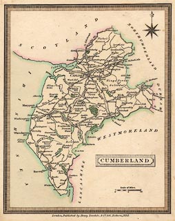
Map, hand coloured engraving, Cumberland, scale about 11
miles to 1 inch, published by Henry Teesdale and Co, 302
Holborn, London, 1830.
|
||

|
Teesdale 1830 | |
| map feature:- | plain cartouche & compass rose & up is N & scale line & sea plain & coast tinted & rivers & lakes & parks & county & settlements & roads & canals | |
| inscription:- |
printed title cartouche, lower right
CUMBERLAND |
|
| inscription:- |
printed bottom
London, Published by Henry Teesdale, & Co. 302, Holborn, 1830. |
|
| scale line:- | 10 miles = 23.1 mm | |
| scale:- | 1 to 700000 ? (1 to 696686 from scale line) | |
| wxh, map:- | 149x187mm | |