 OS 1840s-60s Old Series

|

|
|
|
item:- JandMN (60) image:- © see bottom of page |
click to enlarge |
|
|
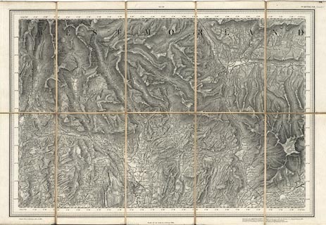
Map, engraving, Kendal, Westmorland, Old Series one inch
map, hachured edition, sheet 98NE, scale 1 inch to 1 mile,
published by the Ordnance Survey, Southampton, Hampshire,
1864, printed from an electrotype taken 1865.
The map includes Kendal and part of Westmorland, and Sedbergh and part of Yorkshire. |
||

|
OS 1840s-60s Old Series | |
| map feature:- | sectioned for folding & mounted & folded (with end cards for protection) & piano key border (4 edges) & up is N & scale line & lat and long scales & rivers & lakes & relief & hill hachuring & woods & forests & county & settlements & roads & railways & canals | |
| inscription:- |
printed top right
98 / No.XCVIII.N.E. (Kendal) |
|
| inscription:- |
printed bottom left, right
Printed from an Electrotype taken in 1865. / Engraved at the ORDNANCE SURVEY OFFICE, Southampton, under the direction of Col. J. Cameron R.E. / The Outline by Edwd. May, the Writing by J.A. Harrison, the Hills by G. de Garlieb. / Published by Coll. Sir Henry James R.E., F.R.S., M.R.I.A. &c. Superintendant October 1864. |
|
| scale line:- | 4+1 miles = 126.4 mm (about) | |
| scale:- | 1 to 63360 ? (nominal) | |
| wxh, sheet:- | 56.5x36.5cm | |
| wxh, map:- | 50x34cm (approx) | |
| wxh, folded:- | 11.5x18.5cm | |