 Speed 1695

|

|
|
|
item:- Dove Cottage : Lowther.37 image:- © see bottom of page |
click to enlarge |
|
|
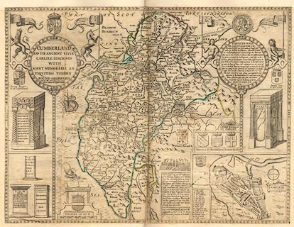
Map, uncoloured engraving, Cumberland and the Ancient
Citie Carlile Described, scale about 4 miles to 1 inch, by
John Speed, amended, published by Henry Overton, the White
Horse without Newgate, London, 1695-1743.
There is an inset map for Carlisle. Pasted in the Lowther scrapbook, vol.3; after the title page. |
||

|
Speed 1695 | |
| map feature:- | picture frame cartouche & coat of arms & vignettes (roman altars) & labelled borders & up is N & scale line & sea moire effect & galleons & sea monsters & coast shaded & rivers & bridges & lakes & relief & hillocks & woods & forests & parks & county & settlements & roads & descriptive text & inset map | |
| inscription:- |
printed title cartouche, upper left
CUMBERLAND / AND THE ANCIENT CITIE / CARLILE DESCRIBED / WITH MANY MEMORABLE AN / TIQUITIES THEREIN / FOUND OBSERVED / Sold by Hen. Overton at ye white / horse without Newgate London |
|
| inscription:- |
printed lower centre
Performed by Iohn Speed and are to be / sould by Henry Overton at the White / Horse without Newgate London altered by HO from original engraving |
|
| scale line:- | 10 miles = 64.8 mm | |
| wxh, sheet:- | 50.5x38cm | |
| wxh, map:- | 504x382m (roughly) | |
| scale 1 to 250000 ? (1 to 248356 from scale line wrongly assuming a statute mile):- | ||
|
from:- Scrapbook, 4 volumes, History of Westmorland and Cumberland Illustrated, of descriptive texts, maps, and prints of views and coats of arms, for Westmorland and Cumberland, assembled by a member of the Lowther Family, late 18th early 19th century. The volumes are quarter bound, with marbled paper on the covers; each has a bookplate inside the front cover. The pages cut from various sources are nicely mounted, two sided pieces set neatly in a window in the scrapbook page. The main content is the whole of the two volumes of The History and Antiquities of the Counties of Westmorland and Cumberland, by Joseph Nicolson and Richard Burn, published London, 1777. Nicolson and Burn volume 1 is in scrapbook volumes 1 and 2, volume 2 in scrapbook volumes 3 and 4. Maps and prints are interspersed to make an illustrated version of the history. Some of the sources of maps and prints have been recognised:- Maps - coast of Cumberland etc by Andrew Dury, 1764; Westmorland and Cumberland by Richard Blome, 1673; sheets from Britannia Depicta, Emanuel Bowen, 1720; Cumberland by John Speed, Henry Overton edn 1695; Cumberland by John Cary 1787. Prints from the Set of prints, 20 engravings, Views of the Lakes etc in Cumberland and Westmorland, drawn by Joseph Farington, published by William Byrne, London, 1789. Note that plate numbers vary from edition to edition of this set. Prints from the Antiquities of Great Britain, drawings by Thomas Hearne, engraved by William Byrne, published by Hearne and Byrne, London, 1786-1807. Prints from Britannia Illustrata, drawings by Leonard Knyff, engraved by John Kip, published London, 1707-1740. Print from A Tour in England and Scotland, by Thomas Newte, published by G G J and J Robinson, Paternoster Row, London, 1788.. Some of the coat of arms are cut from A Display of Heraldrie by John Guillim late Pursuivant at Armes, published London, about 1610-11 to 1755. Coats of arms probably from The Baronetage of England, by Edward Kimber and Richard Johnson, published London? 1771. Pages from The Antiquarian Repertory, by Francis Grose, Thomas Astle, et al, published London, 1775-1809. Text from the Baronetage of England by Collins? Scraps cut from an unidentified gazetteer. At the end is the title page and pp.7-51 from A General View of the Agriculture of the County of Cumberland, by John Bailey and George Culley, published by C Macrae, London, 1794. Individual maps and prints are documented separately; with a note of their position in the scrapbooks. inscription:- : embossed: label on spine: (tatty remains): HI[ ] / [ ]/WEST[ ]M[ ] / [ ] / CUM[ ]M[ ] / ILLUS[ ]T[E ] inscription:- : printed & embossed: bookplate: gold on grey; crest, 6 annulets from the coat of arms, flowers, thistles: LOWTHER |
||