 Cary 1787

|

|
|
|
item:- Dove Cottage : 2007.38.77 image:- © see bottom of page |
click to enlarge |
|
|
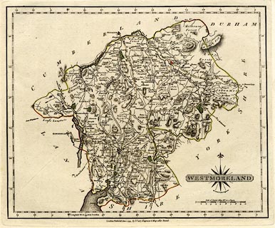
Map, uncoloured engraving, Westmoreland ie Westmorland,
scale about 5 miles to 1 inch, by John Cary, Strand, London,
1793.
Plate 38 in Cary's New and Correct English Atlas. |
||

|
Cary 1787 | |
| map feature:- | compass rose cartouche & compass rose & scale line & lat and long scales (W from London, rectangular projection) & coast form lines & rivers & lakes & relief & hill hachuring & woods & forests & parks & county & settlements & roads & canals | |
| inscription:- |
printed lower right, in and below title cartouche
WESTMORELAND / By JOHN CARY Engraver |
|
| inscription:- |
printed bottom
London : Publish'd Jan 1. 1793, by J. Cary, Engraver & Map seller Strand. |
|
| inscription:- |
printed above scale line
Scale of Statute Miles 69 1/2 to a Degree |
|
| scale line:- | 10 miles = 50.0 mm | |
| wxh, sheet:- | 30.5x24cm | |
| wxh, plate:- | 272x225mm | |
| wxh, map:- | 263x212mm | |
| scale:- | 1 to 320000 ? (1 to 321869 from scale line) | |