 Cooke 1802

|

|
|
|
item:- Dove Cottage : 2007.38.57 image:- © see bottom of page |
click to enlarge |
|
|
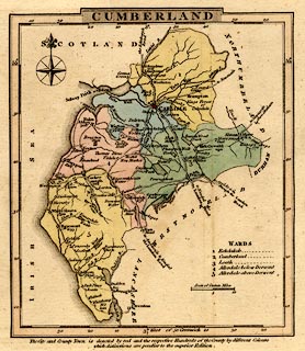
Map, hand coloured engraving, Cumberland, scale about
15.5 miles to 1 inch, by George Cooke, 1802, published by
Sherwood, Jones and Co, Paternoster Road, London, 1824.
Probably from Gray's New Book of Roads, 1824. |
||

|
Cooke 1802 | |
| map feature:- | plain cartouche & compass rose & up is N & scale line & lat and long scales & sea plain & coast form lines & rivers & lakes & parks & county & wards (hundreds) & table of wards (hundreds) & settlements & roads | |
| inscription:- |
printed title cartouche, top
CUMBERLAND |
|
| scale line:- | 10 miles = 16.8 mm | |
| wxh, sheet:- | 12.5x13.5cm | |
| wxh, map:- | 108x125mm | |
| scale:- | 1 to 960000 ? (1 to 957943 from scale line) | |