 Hall 1833

|

|
|
|
item:- Dove Cottage : 2007.38.42 image:- © see bottom of page |
click to enlarge |
|
|
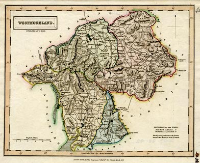
Map, hand coloured engraving, Westmoreland ie
Westmorland, scale about 5.5 miles to 1 inch, by Sidney
Hall, published by Chapman and Hall, 186 Strand, London,
about 1832.
From A Travelling Atlas of the English Counties. |
||

|
Hall 1833 | |
| map feature:- | plain cartouche & north point & scale line & lat and long scales & coast shaded & rivers & lakes & relief & hill hachuring & parks & county & wards (hundreds) & table of wards (hundreds) & settlements & roads & canals | |
| inscription:- |
printed in and below title cartouche, upper left
WESTMORELAND. / ENGRAVED BY S. HALL. |
|
| inscription:- |
printed bottom
London. Published by Chapman & Hall No.186 Strand Mach 1832. |
|
| inscription:- |
printed with scale line
English Miles. |
|
| scale line:- | 10 miles = 47.6 mm | |
| scale:- | 1 to 340000 ? (1 to 338097 from scale line) | |
| wxh, sheet:- | 26.5x21.5cm | |
| wxh, map:- | 242x194mm | |