 Lewis 1831

|

|
|
|
item:- Dove Cottage : 2007.38.41 image:- © see bottom of page |
click to enlarge |
|
|
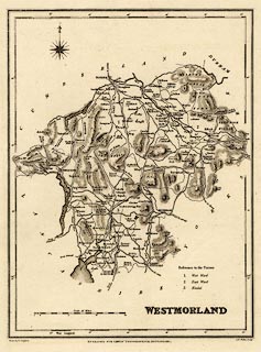
Map, uncoloured engraving, Westmorland, scale about 6.5
miles to 1 inch, drawn by R Creighton, engraved by John and
Charles Walker, published by Samuel Lewis and Co, 87
Aldersgate Street, London, from 1831.
from A Topographical Dictionary of England. |
||

|
Lewis 1831 | |
| map feature:- | compass rose & scale line & lat and long scales & coast form lines & rivers & lakes & relief & hill hachuring & county & settlements & roads & canals | |
| inscription:- |
printed lower right
WESTMORLAND |
|
| inscription:- |
printed bottom left, centre, right
Drawn by R. Creighton / ENGRAVED FOR LEWIS' TOPOGRAPHICAL DICTIONARY. / J. & C. Walker Sculpt. |
|
| scale line:- | 15+1 miles = 63.7 mm | |
| wxh, sheet:- | 25x32cm | |
| wxh, map:- | 173x231mm | |
| scale:- | 1 to 400000 ? (1 to 404231 from scale line) | |