 Rocque 1746

|

|
|
|
item:- Dove Cottage : 2007.38.38 image:- © see bottom of page |
click to enlarge |
|
|
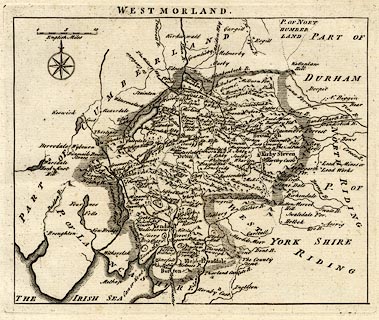
Map, uncoloured engraving, Westmorland, scale about miles
7.5 to 1 inch, by John Rocque, 1746, published London, edn
1769.
Included in England Displayed. Being a New, Complete, and Accurate Survey and Description of the Kingdom of England, and Principality of Wales, London, 1769 |
||

|
Rocque 1746 | |
| map feature:- | compass rose & up is N & scale line & sea plain & coast form lines & rivers & lakes & relief & hillocks & parks & county & settlements & roads | |
| inscription:- |
printed below scale line
English Miles |
|
| scale line:- | 10 miles = 33.1 mm | |
| scale:- | 1 to 490000 ? (1 to 486207 from scale line) | |
| wxh, sheet:- | 26.5x22cm | |
| wxh, plate:- | 205x169mm | |
| wxh, map:- | 195x158mm | |