 Jansson 1646

|

|
|
|
item:- Dove Cottage : 2007.38.23 image:- © see bottom of page |
click to enlarge |
|
|
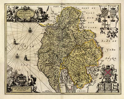
Map, hand coloured engraving, Cumbria and Westmoria, ie
Cumberland and Westmorland, scale about 3.5 miles to 1 inch,
by John Jansson, Amsterdam, Netherlands, 1646.
This example has text pp.163-164, in Dutch, on the reverse and probably comes from the dutch version of the atlas, Nieuwen Atlas, published in editions 1647-59. The map is inchanged from the original 1646 edition. The map has coats of arms for Marcatus, Ran. Meschems, Andrew Harkley, Raphe Nevill, John Duke of Bedford, John Duke of Somerset, John de Foix, and Lord Henry Clifford. |
||

|
Jansson 1646 | |
| map feature:- | scroll cartouche & coat of arms & heraldic border & compass rose & labelled borders & up is N & rhumb lines & scale line & sea plain & galleons & coast shaded & rivers & bridges & lakes & woods & forests & relief & hillocks & parks & county & settlements | |
| inscription:- |
printed title cartouche, upper left
CUMBRIA & / WESTMORIA. / Vulgo / Cumberland & West- / morland. |
|
| inscription:- |
printed lower left of centre
Amstelodami / Apud Joannem Janssonium |
|
| inscription:- |
printed below scale line
Milliaria Anglica quorum quatuor unum Mil : / liaria Germanicum constituunt. |
|
| scale line:- | 10 miles = 68.6 mm | |
| scale:- | 1 to 230000 ? (1 to 234598 from scale line wrongly assuming a statute mile) | |
| wxh, sheet:- | 63x53.5cm | |
| wxh, plate:- | 541x425mm | |
| wxh, map:- | 537x422mm | |
|
||
|
||