 Mill and Heawood 1895

|

|
|
|
item:- Kendal Library (7_5) image:- © see bottom of page |
click to enlarge |
|
|
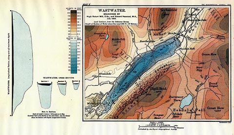
Map, Wastwater, scale 2 inches to 1 mile, with soundings
by Hugh Robert Mill and Edward Heawood, by Bartholomew,
Edinburgh, Scotland, published by George Philip and Son, 32
Fleet Street, London, etc, 1895.
Tipped into The English Lakes, reprinted from an article, On the Bathymetrical Survey of the English Lakes, published in the Geographical Journal, July and August 1895. |
||

|
Mill and Heawood 1895 | |
| map feature:- | plain cartouche & up is N & scale line & depth soundings & depth contours & rivers & relief & contours & layer colouring & table of heights & table of depths & woods & forests & parks & settlements & roads | |
| inscription:- | printed title, | |
| inscription:- |
printed top right
THE GEOGRAPHICAL JOURNAL 1895 |
|
| inscription:- |
printed bottom right
Bartholomew Edinr. |
|
| scale line:- | 1 mile = 51.1 mm | |
| wxh, sheet:- | 36.5x26cm | |
| wxh, map:- | 216x172mm | |
| scale:- | 1 to 31000 ? (1 to 31494 from scale line) | |