 MacKenzie 1893

|

|
|
|
item:- JandMN (222) image:- © see bottom of page |
click to enlarge |
|
|
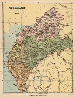
Map, colour printed, Cumberland, scale about 6.5 miles to
1 inch, by F S Weller, published by William MacKenzie,
London, etc, about 1893.
|
||

|
MacKenzie 1893 | |
| map feature:- | table of symbols & up is N & scale line & lat and long scales & lat and long grid & sea tinted & coast line & rivers & lakes & relief & hill hachuring & county & electoral data & settlements & roads & railways | |
| inscription:- |
printed upper left
CUMBERLAND |
|
| inscription:- |
printed bottom centre and right
WILLIAM MACKENZIE, LODON, EDINBURGH & GLASGOW. / F. S. Weller, F.R.G.S. |
|
| scale line:- | 10 miles = 38.9 mm | |
| scale:- | 1 to 410000 ? (1 to 413713 from scale line) | |
| wxh, sheet:- | 25.5x32cm | |
| wxh, map:- | 216x278mm | |