 Jenkinson 1875 map 1

|

|
|
|
item:- JandMN (28_12) image:- © see bottom of page |
click to enlarge |
|
|
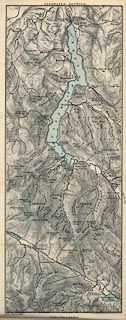
Map, Ullswater Section, Westmorland and Cumberland,
?colour lithograph, scale about 1 mile to 1 inch, by
Stanford's Geographical Establishment, published by Edward
Stanford, 55 Charing Cross, London, 1875.
Tipped in opposite page 313 of A Practical Guide to the English Lake District, by Henry Irwin Jenkinson, 4th edition 1875. The Map includes Ullswater, Grasmere, Thirlmere and Brothers Water; Helm Crag and Helvellyn. |
||

|
Jenkinson 1875 map 1 | |
| map feature:- | colour printed & north point & magnetic deviation & up is NE & scale line & rivers & lakes & settlements & roads | |
| inscription:- |
printed top centre
ULLSWATER SECTION. |
|
| inscription:- |
printed bottom, centre and right
London : Edward Stanford. / Stanford's Geogl. Estabt. 6 & 7 Charing Cross SW |
|
| inscription:- |
printed above scale line
Scale 1 Inch to a Mile. |
|
| scale line:- | 1 mile = 25.4 mm | |
| scale:- | 1 to 63360 ? (1 to 63360 from scale line) | |
| wxh, map:- | 145x377mm | |