 Dispatch 1863

|

|
|
|
item:- Dove Cottage : 2007.38.94 image:- © see bottom of page |
click to enlarge |
|
|
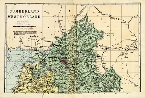
Map, colour lithograph, Cumberland N, part of Cumberland
and Westmorland, scale about 3.5 miles to 1 inch, first
drawn by Edward Weller for the Weekly Dispatch newspaper,
1856-62, edn published by G W Bacon and Co? London, about
1880s?
Plate 9 in the Commercial and Library Atlas of the British Isles. Railways are a prominent feature. Version of this map were published from 1850s to 1930s. |
||

|
Dispatch 1863 | |
| map feature:- | up is N & scale line & lat and long scales (trapezoidal projection) & index grid (1..11, A..G) & table of symbols & table of data (population) & sea tinted & coast tinted & rivers & lakes & relief & hill hachuring & parks & county & electoral data & settlements & roads & canals & railways | |
| inscription:- |
printed upper left
CUMBERLAND / AND / WESTMORLAND / REDUCED FROM THE ORDNANCE SURVEY / BY EDWD. WELLER, F.R.G.S / Divided into 5 miles squares |
|
| inscription:- |
printed bottom
(CUMBERLAND AND WESTMORLAND, NORTH SHEET) |
|
| inscription:- |
printed above scale line
British Statute Miles |
|
| scale line:- | 10 miles = 75.5 mm | |
| scale:- | 1 to 210000 ? (1 to 213158 from scale line) | |
| wxh, sheet:- | 52x34cm | |
| wxh, map:- | 460x301mm | |