button to main menu Linton 1852 map

item:-
Armitt Library : A1158.1
image:-
©  see bottom of page
image, button to large image
click to enlarge


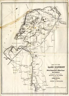
Railway map, uncoloured engraving, Map of the Lake District and the West Cumberland and West Coast Railways, scale about 6 miles to 1 inch, by ?John Linton, engraved by W H Lizars, Edinburgh, Scotland, 1852.
Tipped in at the back of A Handbook of the Whitehaven and Furness Railway, by John Linton, published by Whittaker and Co, London, and by R Gibson and Son and by Callander and Dixon, Whitehaven, Cumberland, 1852.
   Linton 1852 map
map feature:- folded (4x5, zigzag up, zigzag in) & north point & up is NW & scale line & sea plain & coast form lines & rivers & lakes & relief & hill hachuring & parks & settlements & roads & railways
inscription:- printed lower right
MAP OF THE / LAKE DISTRICT / AND THE / West Cumberland and West Coast / RAILWAYS / shewing their connections with / BELFAST AND THE NORTH / as well as with / YORKSHIRE / and the / SOUTH OF ENGLAND.
inscription:- printed bottom right
Engd. by W. H. Lizars, Edinr.
scale line:- 25 miles = 104.1 mm
wxh, sheet:- 36x51.5cm
wxh, map:- 350x488mm
scale:- 1 to 390000 ? (1 to 386490 from scale line)
   notes