 Dugdale 1835

|

|
|
|
item:- JandMN (118) image:- © see bottom of page |
click to enlarge |
|
|
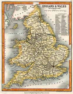
Map, hand coloured engraving, England and Wales with its
Railroads and Canals, scale about 48 miles to 1 inch, by
Thomas Dugdale, drawn and engraved by J Archer, Pentonville,
published by Tallis, London, from 1835.
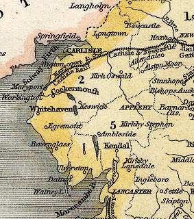
Published in The Curiosities of Great Britain and England and Wales Delineated. Two railways are shown - the Newcastle and Carlisle Railway, authorised 1829, opened 1836, and the Maryport and Carlisle Railway, authorised 1837, opened 1845. The Lancaster Canal from Preston through Lancaster to Kendal is shown. |
||

|
Dugdale 1835 | |
| map feature:- | up is N & scale line & table of symbols & lat and long scales & sea shaded & coast shaded & rivers & lakes & county & table of data (counties) & settlements & canals & railways | |
| inscription:- |
printed upper right
ENGLAND & WALES / With its Railroads & Canals |
|
| inscription:- |
printed bottom right
Drawn & Engraved by J. Archer Pentonville London |
|
| inscription:- |
printed bottom
Engraved for Dugdales England and Wales Delineated. |
|
| scale line:- | 100 miles = 52.9 mm | |
| scale:- | 1 to 3000000 ? (1 to 3042238 from scale line) | |
| wxh, sheet:- | 22x26.5cm | |
| wxh, map:- | 187x239mm | |
|
||