 Dugdale 1835

|

|
|
|
item:- JandMN (119) image:- © see bottom of page |
click to enlarge |
|
|
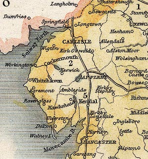
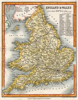
Map, hand coloured engraving, England and Wales, showing
turnpike roads, scale about 47 miles to 1 inch, by Thomas
Dugdale, drawn and engraved by J Archer, Pentonville,
published by Tallis, London, from 1835.
Published in The Curiosities of Great Britain and England and Wales Delineated. The turnpike roads shown in Cumbria are:- from the south through Lancaster, Lancashire; then Kendal, Westmorland; to Carlisle, Cumberland. from carlisle, Cumberland; northwards into Scotland. from the south eastthrough Richmond, Yorkshire; through Appleby, joining the London to Carlisle route, Westmorland. |
||

|
Dugdale 1835 | |
| map feature:- | up is N & scale line & table of symbols & lat and long scales & sea shaded & coast shaded & rivers & lakes & county & table of data (counties) & settlements & roads & turnpike roads | |
| inscription:- |
printed upper right
ENGLAND & WALES |
|
| inscription:- |
printed bottom right
Drawn & Engraved by J. Archer Pentonville London |
|
| inscription:- |
printed bottom
Engraved for Dugdales England and Wales Delineated. |
|
| scale line:- | 100 miles = 53.7 mm | |
| scale:- | 1 to 3000000 ? (1 to 2996916 from scale line) | |
| wxh, sheet:- | 22x26.5cm | |
| wxh, map:- | 187x238mm | |
|
||